These are the best Orangeville hiking trails that you need to visit, both in the town of Orangeville and extending throughout Dufferin County. Orangeville has a few notable hikes right in town, but there's a treasure trove of trails within 10-20 minutes of town (hikes near Mono, Shelburne, Caledon and more).
If you're looking to go hiking near Toronto and the GTA but not actually hiking in Toronto itself, here are some excellent Orangeville and area hikes where you'll be able to enjoy the wonders of nature. I'll share what makes each provincial park, conservation area, and protected greenspace completely unique and special. I'm positive that you'll want to add each of these hikes to your bucket list.
Join the Ontario Hiking Facebook Group
You are also welcome to join our Ontario Hiking Facebook Group - it's a great way to ask questions about hiking in Ontario, share your Ontario hikes, and get inspired!
Come Hiking With Us! Join an Upcoming Group Hike or Tour!
We are so excited to have group hiking adventures within Ontario and beyond. Learn more about how you can join us for a group hiking trip.

Orangeville Hiking Trails: Island Lake Conservation Area

Island Lake Conservation Area is a really special place to go hiking in Ontario. There are numerous meanders through tall trees in the middle of the forest. There are also expansive boardwalks and bridges crossing the lake offering beautiful scenery. Combine wildlife and birds with some of the best hiking trails in Ontario, and you’ll quickly see why Island Lake Conservation Area is so spectacular.
The main trail that wraps around the perimeter of the park is the Vicki Barron Lakeside Trail. It’s about 8km in length, which might seem far to some, but it’s a relatively flat path the entire way. Feel free to walk or cycle this trail and enjoy the everchanging scenery as you explore the park.
Orangeville Hiking Trails: Monora Park
Monora Park in Orangeville is a 40-acre natural park with 18 kms of walking trails, cross-country skiing trails, a picnic shelter, a gazebo and open playing field. When viewing the map on the Mono Parks page, you can see the paths designated as walking trails and those specifically as ski trails. In the winter, the ski trails are not available to hikers, but you can hike on them in the spring, summer and fall.
Here is the Monora Park Loop trail map, as featured on AllTrails. Please note that this full loop may not be accessible in the winter as it is closed to skiing. Speaking of AllTrails, if you haven't yet subscribed to AllTrails+, there's a very special offer for Ontario Hiking readers to snag a subscription at an extremely reduced price.
Orangeville Hiking Trails: Upper Credit Conservation Area
Upper Credit Conservation Area is a 400-acre property with many protected habitats for wildlife, like wetlands, forests and meadows. There are three main hiking trails at the park: Dragonfly Park Trail (0.7km, stroller friendly), Marsh Trail (2.6km, moderate) and the Safari Grasslands Loop (1.7km, easy). There is currently no fee to hike here.
You'll also find the very first section of the Credit Valley Trail here. It's a proposed 100km pathway through the Credit River Valley, from the headwaters in Orangeville to the lakefront in Mississauga. Once its complete, it will surely be one of the best Orangeville hiking trails and I'll have to add it to my list of the top long distance hiking trails in Ontario.
Hockley Valley Provincial Park

Hockley Valley Provincial Park is one of those places that you’ll be thinking about visiting again while you’re still there. It’s that amazing! There are several hiking trails at Hockley Valley Provincial Nature Reserve that form three loop trails, including the Bruce Trail. There is no fee to hike at the Hockley Valley Provincial Nature Reserve.
If you visit in the middle to end of May, you’ll be treated to the sight of thousands upon thousands of trilliums blanketing the forest floor. With these pretty white flowers lining the paths, you’ll quickly fall in love with Hockley Valley Provincial Park. However, if you happen to visit during the other months of the year, I am certain that you’ll love this park equally as much.
Mono Cliffs Provincial Park

Mono Cliffs Provincial Park is one of the most popular parks in southern Ontario. It’s a beautiful park that’s not too far from Toronto, Mississauga, and Brampton. There are a variety of trails and landscapes, including impressive cliffs, intriguing staircases, and gorgeous lookouts.
Some of the top trails at Mono Cliffs include the Cliff-Top Side Trail, the Lookout Trail, the South Outlier Trail, and the Walter Tovell Trail. Give yourself at least a few hours at this park to explore as many of them as you can.
Split Rock Narrows Nature Reserve

Splitrock Narrows Nature Reserve is a protected greenspace, owned by the Bruce Trail Conservancy. It's home to a very unique geological phenomenon. Initially, you’ll stumble upon forests and farmer’s fields. Beyond that, there are rocky outliers, a glacial spillway, steep cliffs, expansive views, and an intriguing crevice system for which Splitrock Narrows is named.
Located near the towns of Shelburne and Mono, Splitrock Narrows isn’t too far from the wildly popular Mono Cliffs Provincial Park. However, the hiking experience at Splitrock Narrows is much quieter than what you’ll find at Mono Cliffs, despite it only being a couple of kilometres down the road. There is a separate parking lot for Splitrock Narrows (it’s free!) and you can hike to Mono Cliffs if you’re looking to extend your hike.
Boyne Valley Provincial Park

Boyne Valley Provincial Park has got it all. Scenic lookouts, dense woodlands, babbling brooks, wooden bridges, and vast meadows. The trail is very well marked with white trail blazers for the Bruce Trail and blue blazes for the side trails.
Murphy’s Pinnacle Side Trail is a highlight of the park. It’s only a quick jaunt up the hill for incredible views of your surroundings. Once you visit the viewpoint at the end of Murphy's Pinnacle Side Trail, take the time to hike the full loop around the park (around 6km).
Orangeville Hiking Trails: Alton Grange
Alton Grange is a 350-acre tract where two bodies of water converge and flow south, Shaw's Creek and the Credit River. There are a variety of protected habitats, including fragile wetlands, hardwood and mixed forest, vast meadows and an open flood plain. Hiking here is such a treat as you'll walk through diverse ecosystems and experience wild, natural beauty.
There are four access points, two parking areas, and five trails in total (including a Bruce Trail side trail). The best trail map for Alton Grange can be found on their official website. Please note that the boardwalks are closed until they can be repaired. You may wish to hold off visiting until the boardwalks are back.
Glen Haffy Conservation Park
The Glen Haffy Conservation Park is a property maintained by Toronto and Region Conservation Authority (TRCA). It's a very peaceful spot where you can hike trails that meander through mature forests along the Niagara Escarpment and the Oak Ridges Moraine. Please note that this park is only open seasonally and closes in the winter.
There are four trails at Glen Haffy Conservation Park: the Green Trail (1.3km), the Blue Trail (2.5km), the Red Trail (2.7km) and the Bruce Trail (4km in the park and continues outside of the park). Glen Haffy also features three large picnic areas and a fishing pond.
Orangeville Hiking Trails: The Bruce Trail

The Bruce Trail is the oldest and longest continuous marked hiking trail in Canada. It runs along the Niagara escarpment in southern Ontario between Niagara and Tobermory. How long is the Bruce Trail? It’s just about 900km in length with over 400km of side trails. The Bruce Trail Conservancy (BTC) is responsible for protecting 16,000 acres of land.
The Bruce Trail and its side trails make appearances at several of the parks in this Orangeville hiking trails guide, including Forks of the Credit Provincial Park, Mono Cliffs Provincial Park, Boyne Valley Provincial Park, Splitrock Narrows Nature Reserve and more. The best thing about the Bruce Trail? It's a continuous hiking trail, so you can hike from one park to the next on it across a long distance. It's one of the best long distance hiking trails in Ontario.
Upper Grand Trailway
The Upper Grand Trailway is an abandoned CPR rail trail, transformed into a multi-use trail. It's 10.5km in length, available in all seasons, and it's free to use. This resurfaced trail allows hikers, cyclists, and cross-country skiers to experience the wonders of the countryside.
I wouldn't say that this is the best hiking trail near Orangeville as it's a relatively flat path through the country. It's likely more suitable for cyclists than those walking, but it does allow access to a few places of interest: the quaint village of Grand Valley, an old train station (now a private residence), and views from a bridge over Boyne Creek.
Forks of the Credit Provincial Park

Forks of the Credit Provincial Park has amazing hiking trails that are wonderful in all seasons. From vast meadows to stunning escarpment views, the Forks of the Credit trails have really got it all. It’s a great park if you’re looking for some exercise outdoors, the chance to view a gorgeous waterfall, and nature hikes along the river.
The hiking trails at Forks of the Credit Provincial Park aren’t boring old flat paths. There are many hills up and down the escarpment, so it might be a little challenging for those who aren’t used to hiking a lot of hills. I’d consider it to be a moderate hike for Ontario trails, but I still think that beginners could tackle this one perfectly well. There are several trails within the park, including sections of the Bruce Trail and the Trans Canada Trail.
Belfountain Conservation Area

Belfountain Conservation Area is a place to discover nature and local history. Most people visit to experience views of the iconic suspension bridge and gorgeous cascading waterfall. There are four fantastic hiking trails at Belfountain Conservation Area, including the Gorge Trail and the Riverside Trail.
This conservation area recently had some major renovation work and improvements. New to the park, there is one covered lookout point with benches and a railing. You’ll share this lookout space with the new Fox Folly sculpture, and it's where you can enjoy some more beautiful views of the park. Please note that Belfountain Conservation Area is open seasonally, and you may need to book your park reservation in advance.
Cheltenham Badlands

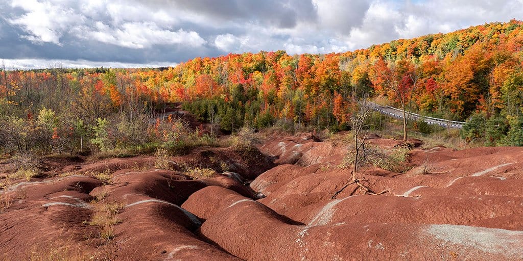
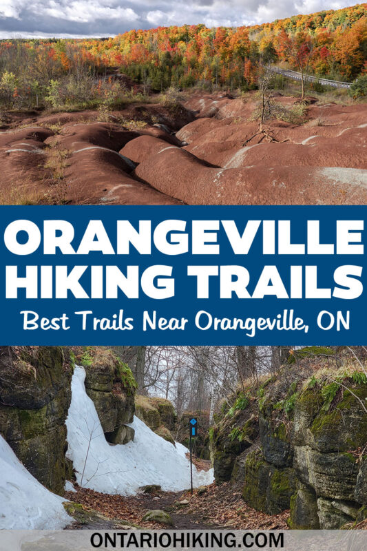
While I wouldn't exactly say that the Cheltenham Badlands are home to the best hiking trails in Orangeville, it does feature one of the most interesting natural formations in the province. Plus, it's right on the Bruce Trail, which is one of the best Orangeville hiking trails, hands down.
You can admire the intriguing reddish-orange little hills from the boardwalk next to the Cheltenham Badlands. The Badlands themselves are off limits to hikers as to protect the terrain itself. How did this landscape come to exist in the middle of Ontario?
Early farming practices combined with tree removal caused the shallow topsoil to erode, exposing the shale. Then, the Queenston shale began to rapidly erode away when it was exposed to rain, snow, freezing and thawing, leaving behind the unique badlands topography that you see today. You can combine a trip to the Cheltenham Badlands with other Orangeville hiking trails mentioned in this article if you're seeking a lengthier trek.
Ken Whillans Resource Management Area
Ken Whillans Resource Management Area is maintained by Credit Valley Conservation (CVC), and it's a lovely spot to get out in nature. While there are only a few short trails here, it's worth a visit if you don't mind a shorter hike. Please note that the Ken Whillans Resource Management Area is open from spring to fall, and closed in the winter.
The Harvest Trail (0.9km) is an easy, stroller-friendly walk. The Credit Valley Trail (1.4km) also runs through this park and alongside the Caledon Trailway, an abandoned rail line linking Hamilton with Barrie. While the main focus of the Ken Whillans Resource Management Area are its fishing ponds, you can also go for a short walk here, too.
What to Bring on a Hike
A proper pair of hiking shoes is an absolute must. It’s also a good idea to bring sunscreen and lots of water, too. My water bottle of choice is the GRAYL Purifier because you can drink ANY water from any source, no matter what. Water from lakes, streams, rivers, public restrooms, you name it. It's the world's fastest portable purifier.
Don’t forget to pack some bug spray because there can be biting bugs depending on the time of year. Even if there aren't any signs, it’s safe to assume that ticks are all over Ontario hiking trails. Protect yourself against ticks by reading our guide to avoiding ticks on the trails.
For amazing deals on hiking products like backpacks, boots, clothing, and gear, check out the Decathlon Canada shop!
Where to Stay Near Orangeville
Looking to visit several Orangeville hiking trails but don't live in the area? Why not make a little staycation out of it! Use the handy map below to browse local accommodations and hotels. Enter your travel dates for more precise information, and click on each hotel to learn more.
More Hikes in York, Durham and Headwaters Region
Looking for more hikes in the area? Here are all of our hiking guides for York Durham Headwaters region:
- Belfountain Conservation Area
- Boyne Valley Provincial Park
- Mono Cliffs Provincial Park
- Cheltenham Badlands
- Hockley Valley Provincial Park
- Forks of the Credit Provincial Park
- Island Lake Conservation Area
- Nokiidaa Trail
- Thornton Bales Conservation Area
- Greenwood Conservation Area
- Cold Creek Conservation Area
- Happy Valley Forest
| Follow Ontario Hiking on Social Media! Instagram | Facebook | Twitter | Pinterest | Newsletter | Join the Community |

Become an Ontario Hiking Supporter!
Join the Ontario Hiking Patreon and you'll become a VIP member of the Ontario Hiking community! You'll receive ad-free, downloadable hiking guides with new guides added weekly. Plus, there are many more perks! Become an Ontario Hiking Supporter today!

Check out the Ontario Hiking Shop!
Inspired by adventures and nature. Ontario hiking and Bruce Trail apparel & accessories, designed by me.